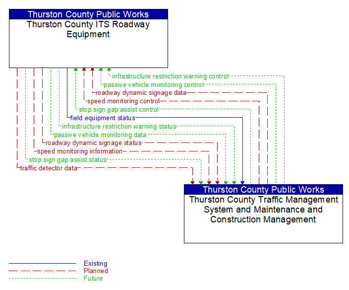
Interface: Thurston County ITS Roadway Equipment - Thurston County Traffic Management System and Maintenance and Construction Management
Architecture Flow Definitions
field equipment status (Existing) Applicable ITS Standards
Reports from field equipment (sensors, signals, signs, controllers, etc.) which indicate current operational status.
infrastructure restriction warning control (Future) Applicable ITS Standards
Information used to configure and control infrastructure-based sensors that measure the size and weight of passing vehicles and associated signage that provides infrastructure restriction advisories and warnings to drivers.
infrastructure restriction warning status (Future) Applicable ITS Standards
Infrastructure restriction warning application status reported by the RSE. This includes current operational state and status of the RSE and a record of measured vehicle dimensions and alerts and warnings issued.
passive vehicle monitoring control (Future) Applicable ITS Standards
Control commands used to control detection systems that rely on infrastructure-based identification of individual vehicles to measure travel times and other related measures by identifying the same vehicle at different points in the network. Related technologies include bluetooth readers and license plate recognition systems.
passive vehicle monitoring data (Future) Applicable ITS Standards
Time stamped identifiers that identify the vehicles that have passed through a detection zone.
roadway dynamic signage data (Planned) Applicable ITS Standards
Information used to initialize, configure, and control roadside systems that provide driver information (e.g., dynamic message signs, highway advisory radio). This flow can provide message content and delivery attributes, local message store maintenance requests, control mode commands, status queries, and all other commands and associated parameters that support remote management of these systems.
roadway dynamic signage status (Planned) Applicable ITS Standards
Current operating status of dynamic message signs, highway advisory radios, or other configurable field equipment that provides dynamic information to the driver.
speed monitoring control (Planned) Applicable ITS Standards
Information used to configure and control automated speed monitoring, speed warning, and speed enforcement systems.
speed monitoring information (Planned) Applicable ITS Standards
System status including current operational state and logged information including measured speeds, warning messages displayed, and violation records.
stop sign gap assist control (Future) Applicable ITS Standards
Configuration and control of detectors that monitor traffic on the major road and signs that provide stop sign gap assist alerts and warnings to vehicles on the minor road.
stop sign gap assist status (Future) Applicable ITS Standards
The current operational state and status of the field controller, sensors, and signs that support the stop sign gap assist application.
traffic detector data (Planned) Applicable ITS Standards
Raw and/or processed traffic detector data which allows derivation of traffic flow variables (e.g., speed, volume, and density measures) and associated information (e.g., congestion, potential incidents). This flow includes the traffic data and the operational status of the traffic sensor system.